Page 1 of 2
Savuti & Moremi track conditions (till end of July)
Posted: Sat Mar 20, 2010 10:54 am
by come-along.nl
Here's an update from selfdrive people who were at the scene 2 weeks ago:
A picture taken two weeks ago of the 'Stony' bridge been constructed to give selfdrivers a way to cross the Savuti channel:
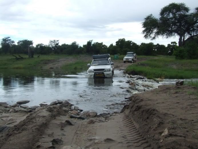 Tracks between Savuti & North Gate (Khwai):
At Camp Savuti the channel is relatively easy to cross. The tracks in the Marsch are off limit, so to get to Mababe Gate you have to take the less attractive track along the sandridge. This section is easy negotiable beside one or two 'pools'. Then it's the new transit road to Khwai village. The real challenge started when we reached the Khwai river some 3 kilometers north of North Gate. The waterlevel was so high that we had thoughts of turning back... However we met some friendly roadworkers who told us not to quit only 3 K's from our goal. After they got a truck just in case we got stuck we made an attempt to cross the water. A local driver arrived and went straight in without hesitation! He got stuck:

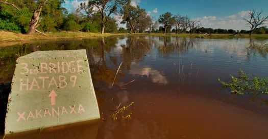
Tracks between Xakanaka and 3rd Bridge:
First: We've been told that it's was impossible to reach Xakanaxa from North Gate (Khwai). So we went to South Gate.
On the stretch to South Gate again deep pools of water. It's not recommended to do this part in Moremi on your own. The track from South Gate to 3rd Bridge could not be made without a 'snorkel' so we decided to go to Xakanaxa. The rains and our fear of getting stuck made us turn round and head for safety back to South Gate. However theb route should be possible so we are told...
This is the current situation. 2-3 weeks ago we had two days with both 100mm of rain. The situation is considered by experienced Botswana Selfdrivers as: 'Extreme'...
Source: Namibia-forum
Re: Update: Current Savuti & Moremi track conditions
Posted: Sun Mar 28, 2010 9:46 am
by come-along.nl
Four weeks ago we were in Moremi. We drove from South Gate and Third Bridge to Xakanaxa. The drive back through the Mopane forest also didn't cause us any problems. The drive from South Gate into the direction of the Khwai river was a problem. We were told: 'Not passable' and turn around.
The tracks from Chobe Riverfront to Savuti via Kachikau wasn't a problem. Small gamedrives in the Savuti area are possible. The Marsch is no go and prohibited!
The drive from Savuti along the Sandridge to Mababe Gate shows no major problems. Marsch route is off limits.
Source: namibia-forum
Update: Current Savuti & Moremi track conditions
Posted: Tue Apr 20, 2010 7:44 pm
by come-along.nl
I've received another update on the situation in Moremi & Chobe NP:
It's in German but I will translate this in due course
 We are back and can give an update on our own experiences (Date of travel March till April 7, 2010):
Maun - South Gate: Nothing new, Ok.
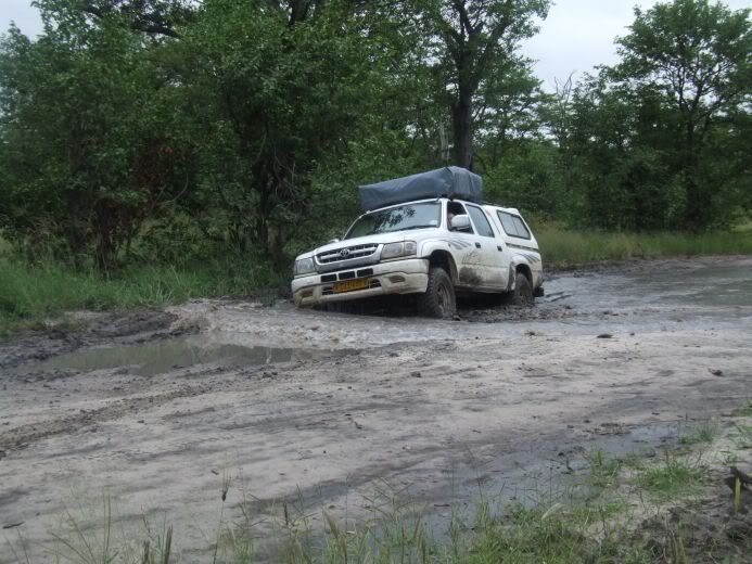
South Gate - Third Bridge: Officially open, but we turned back after a few kilometers. Two days later we met people whom arrived at 3rd Bridge around 9.00 PM : Hat to dig the in the mud a couple of times...
South Gate - Xakanaxa: First half the tracks are 'littered' with big pools, second half is better because of the sand that is hardened because of the rains.
Xakanaxa - Third Bridge: No Problems, All driveable
Xakanaxa - North Gate (Along the river): Closed (Flooded)
South Gate - North Gate: Bis auf die kritische Stelle bei ca. Km 14 kein Problem, teilweise Tiefsand, gut zu fahren, da nass.
North Gate - Savute: Der Khwai River beim North Gate über die neue Brücke, dann durch das Dorf und nun die erste Khwai Flussquerung ohne Brücke. Wassertiefe weniger 70 cm. Dann auf der neuen Strasse weiter Richtung Norden. Diese Strasse ist z.B. auf T4A Ausgabe Dezember 2009 noch nicht aufgenommen. Alle Tracks von T4A in diesem Gebiet führten zu viel Wasser. Die neue Strasse endet jedoch abrupt wieder am Fluss, hier den kurz vorher abbiegenden Tracks gegen Osten folgen und den Khwai nochmals queren. Wenige cm tiefer als die erste Khwai Querung, jedoch diverse Varianten möglich. Wir folgten dem Ratschlag von einem LKW der Dorfbewohner nach Mababe brachte. Sonst hatten wir die Querung zuerst zu Fuss ausloten müssen. Danach wieder auf der neuen Strasse. Die Marsh-Road nach Savute ist gesperrt. Die Strasse über Mababe Gate und dann quasi der Sandridge nach ist am Anfang mit viel Wasser-Löcher, später dann nasser Sand.
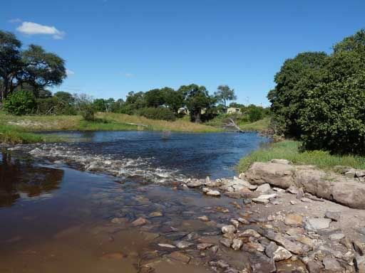
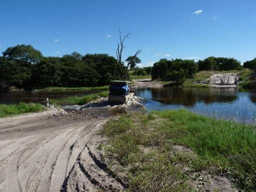
Savute - Ngoma: Savuti Channel ist bequem über eine Furt aus Steinen zu queren. Einige kritische Stellen bis Goha Gate (Mud) welche jedoch umfahren werden können. Nach Goha Gate über Sandridge, Tiefsand, infolge Nässe jedoch sehr gut zu fahren. Strasse von Kachikau bis Ngoma: eine einzige Baustelle, absoluter Horror zu fahren.
Chobe-Riverfront: Main Track kein Problem, die meisten Strassen gegen den Fluss sind schlichtweg nicht existent, weil überall Land unter. In Kasane teilweise nicht alle Unterkünfte mehr verfügbar: Land unter. Der Chobe wirkt auf den ersten Blick wie ein See mit Inseln - Fluss als solches kaum erkennbar.
Source: Rajang - namibia-forum
Re: Update: Current Savuti & Moremi track conditions
Posted: Sat May 01, 2010 3:47 pm
by come-along.nl
The water has reached the Savuti Campsite (Ranger camp in the back):
Source: Joachim - namibia-forum
Re: Update: Current Savuti & Moremi track conditions
Posted: Sat May 08, 2010 9:29 am
by come-along.nl
On 20 april we travelled from Savuti campsite to Khwai.
The new road to Khwai is very good but at the end near Khwai, there are
3 rivers to cross.
With the Defender, no problem, water just under the front cover.
For the second river you need to take a small track before the river
to the left because the main track is to deep in the river.
Otherwise no problem.
Michel
Source: overland forum
Re: Update: Current Savuti & Moremi track conditions
Posted: Thu May 20, 2010 9:09 am
by come-along.nl
A Week in Moremi - 08:20 pm
09 May 2010
I have come to the Earth Touch film camp to assist Jason, while Brad is on leave. I have been friends with Jason since we worked together 2 years ago in the Makgadikgadi pans and I jumped at the chance to join him in Moremi. The last time I was here, was over the New Year and a lot has changed. Most areas are almost unrecognisable. It’s all due to the annual flood of the Okavango Delta having arrived in the last month. As such, my week has been rather interesting. It quite remarkable to witness how the flood has affected the roads and crossings of Moremi. Some crossing are now impassable and home to large crocodiles; floodplains, once dry, are now small lakes; roads have become rivers.
Photo taken near 3rd Bridge (May 9, 08.20 AM):
Source: moremi.earth-touch.com
Re: Update: Current Savuti & Moremi track conditions
Posted: Thu Jun 03, 2010 7:45 am
by come-along.nl
Source: Heiko (Bush Ways Safaris)
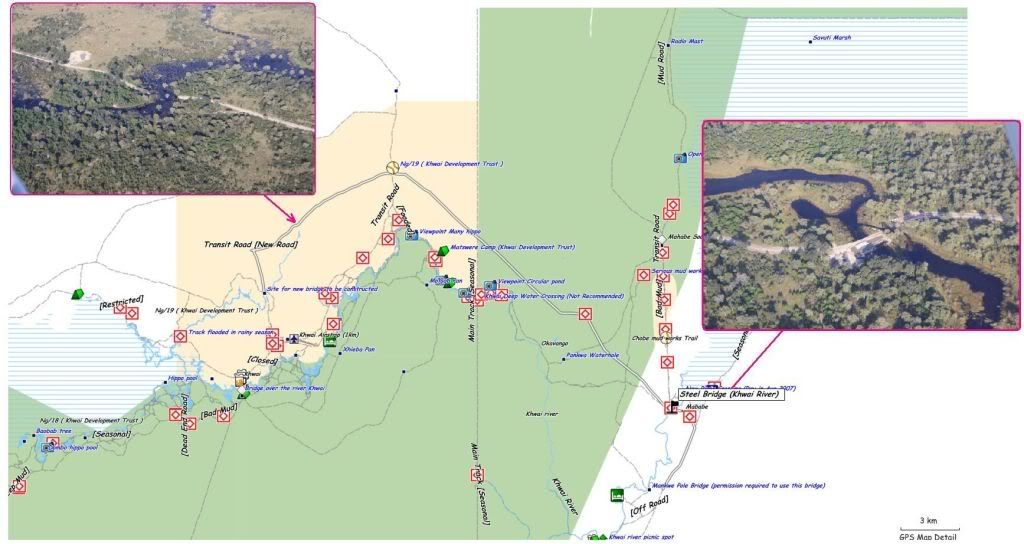
Current situation tracks in Moremi (June 10)
Posted: Fri Jun 11, 2010 9:15 pm
by come-along.nl
Current "No Go" tracks in Moremi:

This map is a Sattellite image taken on June 10.
p.s. Red is "No go"...
Re: Update: Current Savuti & Moremi track conditions
Posted: Sun Jun 13, 2010 9:45 pm
by come-along.nl
For those who are interested, here is the latest update on road conditions around the Delta sent to me by someone based in Maun who does vehicle recovery in the area. "The road to Moremi from Savute, ie through the Khwai gate, is closed. So the route from Savute to Moremi is via Mababe Village, where there is a new bridge, then skirting the reserve through Sankuyo Village and coming in through the normal southern entrance- South Gate. There is also no link between Khwai and Xaxanaka- you have to go down to South Gate and then up to Xaxa. Likewise, to get to 3rd Bridge you have to go via Xaxanaka - no direct link from South Gate.
All driving along tracks in the north must be done with caution and water crossings walked first. The Savute channel is running very strongly but there is a stone causeway in place. Vehicles are crossing but it is getting ever deeper - travellers must check at Ngoma or Goha before going further as conditions are not static.
We are seeing rising water in Maun too with low lying areas already flooded. We normally have five access roads to our house, three are flooded.
Source: Marc Hall
Re: Update: Current Savuti & Moremi track conditions
Posted: Mon Jun 21, 2010 7:11 am
by kingshaka
MOREMI CONDITIONS (May 21 - 25)
Water still making many tracks impassable, it's receding but slowly so it might still be as I describe it.
Road from tar to South Gate has sections with quite a bit or corrugation.
South Gate to 3rd Bridge: direct route via Xini lagoon not passable, used Xakanaxa road and took fork to the left before reaching Xakanaxa campsites. No problem.
3rd Bridge to Khwai/North Gate not passable at some point before Dombo hippo pools, you have to go to S. Gate and then reach Khwai from there through direct route but we didn't go to Khwai as we had originally planned.
Game drives from 3rd Bridge: we were told by other fellow selfdriver that Khwai area was surrounded by water and there was not much to do and see there so we decided to stay on 3rd B. four nights instead of two. Think was a good choice, lots of game and fun with water crossings. No much mud. For every mud hole there is already a little detour track around it, sometimes through the bush though, lots of scratching from vegetation.
3rd Brigde from Xaxanaka: we were advised by our car rental guy to take left immediately after reaching the other end of the bridge, danger of getting stuck in biggish pool in the middle (they had to recover one customer a few days back). Seemed good advice and had no problems.
1st and 2nd Bridge broken. Actually one of them, think its 2nd B. was still holding up but in such a bad shape that better go through water. Met this SA guy that went through it but had to use all his firewood to put in on the gaps left by the loose logs.
Waded both crossings on foot to check depth, water around knee level, compact sandy bottom, deepens very gradually, easy for experienced 4x4ers but for a first timer... did it in low range and diff-lock just in case (perhaps an overkill in this case but I din't care). Entered the water in 2nd gear with a little bit of momentum at about 2000 revs so still plenty of power left to slowly push the throttle further while in the middle of the crossing. Hope this must be the way. These landies feel like tractors and seem to go through anything. I'm starting to like them.
2nd bridge is done through the left side as you come from 3rd B., the right seemed easier but there was a nasty looking hard mud step at the edge of the water on the far end, looked easy to loose momentum/traction as you come out of the water and get stuck there. 1st Br. done through the right. (check this because it could be the other way round with the bridges, my memory is not so good but I'm almost certain is like that). Apparently the road becomes impassable somewhere after 1st B. but never reached this point myself, mostly did the Mboma routes which seemed to have more game.
source: 4x4 commmunity forum