Rivers swollen as country prepares for floods
There's no let-up in the amount of rain that is swelling rivers throughout the country and in neighbouring Namibia and Angola. The peak of this year's annual flood continues to be expected to be much higher than last year. Some forecasts are that water levels could reach as high as two metres above previous figures and if so, it would be the highest since the mid-1980s
Botswana, Mozambique, Namibia, Zambia and Zimbabwe have forecast that serious flooding could affect tens of thousands of people, and damage infrastructure, crops and homes, the UN Office for the Coordination of Humanitarian Affairs said in a new update.
Weather forecasters predict “normal to above normal rains” – and so far they have not been wrong. In Maun, for instance, 37.2mm of rain has been measured over the last seven days with more forecast. Botswana is making urgent arrangements to prevent a disaster situation by setting up a distribution centre at Dukwi, near Nata, in case emergency help is needed in the deltas and in other parts of northern Botswana. Tents, cooking utensils, bedding and other commodities are being stored.
At Rundu, in Namibia, the water level is already higher than last year and this indicates that water flowing into the Okavango River and delta in Botswana will also be higher. These fears have been realised as water is already flooding in at Mohembo, in north west Botswana, at a higher rate than for the corresponding period last year. It is so far the highest for this time of the year since 1984, according to latest statistics.
At Maun, the level of water in the Boro and Thamalakane river, tributaries of the Okavango River and which in turn supply Lake Ngami and the Boteti River, is appreciably higher than for the last two seasons. The Zambezi River is also in flood and warnings of high water and potential damage to properties have been issued all along the Caprivi Strip in Namibia. In addition, the Chobe River, a tributary of the Zambezi, is also rising much earlier this year than in years past. Whatever happens in the Zambezi and Chobe also has a bearing on the Okavango delta, where for the first time in two decades the Savuti Channel came down in flood last year. Already safari lodges and camps are preparing for the worst scenarios, with lodges stocking up on foodstuffs, while isolated villages throughout the region have been placed on alert as well.
source Ngami Times
Floods in Botswana 2011...
-
come-along.nl

- Posts: 908
- Joined: Mon Mar 15, 2010 2:49 pm
- Contact:
Floods in Botswana 2011...
Last edited by come-along.nl on Fri Apr 06, 2012 10:20 pm, edited 2 times in total.
-
come-along.nl
- Posts: 908
- Joined: Mon Mar 15, 2010 2:49 pm
- Contact:
Re: Floods in Botswana 2011...
Is this the Start of the Rise of the Okavango in the Maun Area? I wonder what 2011 will bring...
You do not have the required permissions to view the files attached to this post.
-
come-along.nl
- Posts: 908
- Joined: Mon Mar 15, 2010 2:49 pm
- Contact:
Re: Floods in Botswana 2011...
OKAVANGO FLOOD CAUSING HAVOC
By Bright Kholi
Floodwaters in the Okavango River have already left many areas in the upper and lower panhandle inundated, leading to massive damage to property and roads. Experts expect the downstream areas – including Maun - to be affected just as much. The timing of the flood is a month earlier than last year's – the end of April is the predicted date for the water to reach Maun. This week, areas such as Mohembo East, Nxamasere, Ikoga, and Gudigwa were trying to come to terms with the water that has submerged roads and property, and the water treatment plant in Sepopa was this week inaccessible as the road was submerged. At Etsha 13, the water is already in the village behind the clinic and is expected to move further into the centre of the village. Residents of all the areas from the panhandle and downstream to Maun, Toteng and Rakops are still reeling from last year's floods in the Boro, Thamalakane and Boteti rivers that damaged property and crops, with many people being evacuated to higher ground. In an interview with The Ngami Times this week, Kgosi Moneya Dibebe, of Nxamasere, told of how the water has already submerged the community hall, post office and a gravel road and is now creeping towards VDC houses which house civil servants. Dibebe said the water was also approaching the school, fearing a repeat of what happened last year when many of his villagers had to be evacuated to higher ground. He regretted however that some have since returned to their flood prone yards and are faced with a similar scenario. Dibebe feels that this year's floods may have a more serious impact than last year as the water has arrived much earlier. In Etsha 13, Kgosi James Sevako told The Ngami Times that the floodwater is already in the village behind the clinic and appears to increasing. He said if the water reaches where it did last year; it will cause major damage. “Last year, the flood caused a lot of damage to people's houses and about 290 people were evacuated to higher ground,” he said. He said none of those evacuated returned to the low lying areas but he is concerned about the safety of his people as the water brought with it snakes and crocodiles. The flood however, is a good source of drinking water for livestock. In Gudigwa it was a race against time this week as the authorities were reconstructing culverts and the roads that were damaged the flood last year. The assistant district commissioner, Okavango District, Orapeleng Modimoopelo, said this week that they are rebuilding culverts which were damaged by water in Gudigwa and another one which is always submerged when the flood arrives. A portion of road which was washed away last year is being rebuilt. Modimoopelo added that in the entire Okavango they anticipate that the damage caused “will be minimal because people who were affected last year were allocated new plots on high ground and did not return to their old yards. We are checking every day and we have teams of people in all areas who report to us any changes in the water levels.” Modimoopelo warned that residents of affected villages should stay away from the river. According to Naidu Kurugundla, of the department of Water Affairs in Maun, the new flood is expected to arrive in Maun in the last week of April - a month earlier that last year. Water intake at Mohembo reached a highest discharge of 1 017.239 cubic metres per second with a level of 4.001 metres on March 24 and has since started declining. This is lower than 1 150.239cubic metres/second and a water level of 4.24 metres that was recorded at Mohembo as the highest last year. Kurugundla said the flood will almost be the same as last year and will inundate areas that it affected last year. Since March 24, the discharge and levels have started declining respectively as follows: March 26, 981.518cusecs and 4.001metres, March 27 was 988.759cusecs and 3.990 metres; March 28 was 982.179cusecs and 3.956 metres and for March 29 was 959.605 cusecs and 3.925 metres. He said properties that still lie in flood plains will be affected, adding that those involved should start working on moving people. Piotr Wolski, an associate professor at the Okavango Research Institute, said this week when giving a talk in Maun that the floods this year will be comparable to that of last year. The Thaoge river is expected to receive more water again as it did last and which forced the closure of Toteng Bridge, which has again been closed for additional repair work to be undertaken. He however could not specifically say what the flood would look like especially as it reaches down stream, Maun and beyond. Following last year's flood, the water went all the way to Lake Xau in the Boteti area for the first time in over 30 years and the same is expected this year.
source: Ngami Times
https://www.selfdrive4x4.com/en/
www.come-along-safari.com
Discover unspoiled Africa by 4x4, individual freedom and a true African adventure!
www.come-along-safari.com
Discover unspoiled Africa by 4x4, individual freedom and a true African adventure!
-
come-along.nl
- Posts: 908
- Joined: Mon Mar 15, 2010 2:49 pm
- Contact:
Re: Floods in Botswana 2011...
source: Ngami TimesStand-by for a bigger flood
Maun could have an even bigger flood by the end of June than the area experienced last year judging from current water levels in the Okavango River and delta. The levels at Mohembo – where water from Angola's eastern highlands enters Botswana – are above the maximum registered last year by 3 cm, the highest since 1984.
This has resulted in fears that Maun could see a 40cm rise in levels on the Boro and Thamalakane rivers, resulting in widespread flooding which could reach Rakops on the Boteti River.
Already the Boronyane River in the Sedie area has come down in flood for the second time in three decades and water levels on other rivers are also increasing. Hydrologists studying the potential for flooding say the difference between the peak water levels of 2009 and 2010 at Nxaraga, for instance, was approximately 10 cm.
The current 3cm above last year's peak at Nxaraga translates into peak water levels in Maun at 10cm higher than last year and if water levels at Nxaraga continue to rise from 1.96 metres on May 23 in the next month to about 2.03 metres, the peak in Maun will be 40 cm above last years.
At Island Safari Lodge, the water level on May 24 was 3.80 metres compared to last May when it stood at 4.30 metres. “The bottom line is that the flood in Maun is going to be higher than last year, that's for sure,” said Piotr Wolski, Associate Professor (Hydrology) at the Okavango Research Institute in Maun.
https://www.selfdrive4x4.com/en/
www.come-along-safari.com
Discover unspoiled Africa by 4x4, individual freedom and a true African adventure!
www.come-along-safari.com
Discover unspoiled Africa by 4x4, individual freedom and a true African adventure!
-
kingshaka

- Posts: 276
- Joined: Wed Mar 31, 2010 10:30 pm
Re: Floods in Botswana 2011...
Okavango Flood update - May 30, 2011
After the extremely high flood levels of last year, the 2011 flood is continuing with the Delta's wet cycle and it is even exceeding last year's big flood.
The chart below shows data as of May 30, 2011...
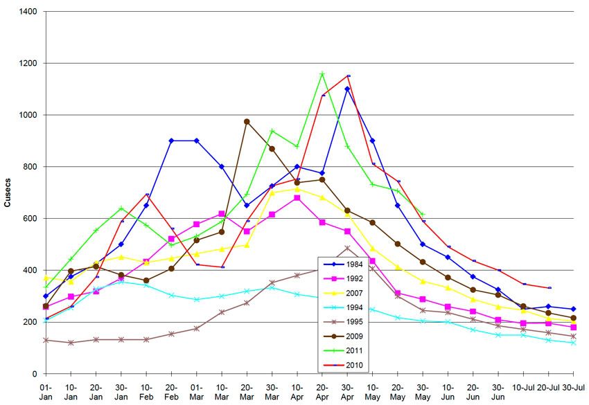
Read on: www.eyesonafrica.net/updates/flood-update.htm
After the extremely high flood levels of last year, the 2011 flood is continuing with the Delta's wet cycle and it is even exceeding last year's big flood.
The chart below shows data as of May 30, 2011...
Read on: www.eyesonafrica.net/updates/flood-update.htm
-
MichelG
- Posts: 15
- Joined: Mon Jun 20, 2011 9:22 pm
Re: Floods in Botswana 2011...
Latest news from the Ngami Times!
Toteng - Maun road closed at the Xutego River at Sitatunga due to flash flooding.
http://www.ngamitimes.com/index.html
Regards,
Michel
Toteng - Maun road closed at the Xutego River at Sitatunga due to flash flooding.
http://www.ngamitimes.com/index.html
Regards,
Michel
-
come-along.nl
- Posts: 908
- Joined: Mon Mar 15, 2010 2:49 pm
- Contact:
Re: Floods in Botswana 2011...
We have reason to believe that this is 'Old news'...MichelG wrote:Latest news from the Ngami Times!
Toteng - Maun road closed at the Xutego River at Sitatunga due to flash flooding.
http://www.ngamitimes.com/index.html
We are checking with our contacts in Maun and will get back to you when we know more
Cheers, Hans
https://www.selfdrive4x4.com/en/
www.come-along-safari.com
Discover unspoiled Africa by 4x4, individual freedom and a true African adventure!
www.come-along-safari.com
Discover unspoiled Africa by 4x4, individual freedom and a true African adventure!